
Cheffadène Fm
Type Locality and Naming
A cliff (18 m) at 63 km S.-S.-E. of Tiffa. Faure, 1966; It takes its name from the small village of Cheffadène.
References: Furon, 1964; Faure, 1966; Fabre et al., 1983; Meister et al., 1994; Konaté et al., 2019.
Synonym: Cheffadene Fm, Grès de Cheffadène; Equivalent(s): Alanlara Fm; Ezerza Fm; Ezerza-Cheffadène Fm
Lithology and Thickness
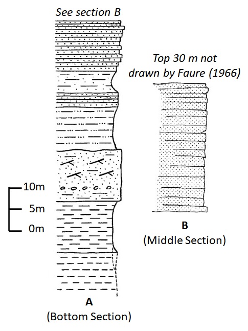
Ferruginous sandstone, beige, coarse levels with cross-bedded stratifications, white clay. According to Furon (1964), the upper part contains some marine levels. Compared to the Ezerza Fm, the Cheffadène Fm displays thick sandstone beds; the clays are above all kaolinitic, and the limestones have practically disappeared (Fig. 1). Its thickness is 200 m.
[Figure 1: The Cheffadène Fm. Section “A” is taken on the cliff, 5 km south of Cheffadène. Section “B” was measured up to 22.5 km south of Cheffadène (Faure, 1966, pages 244-245). Note that up to 30 m of the formation is missing above section “B”.]
Relationships and Distribution
Lower contact
Underlying unit is the Tiffa Fm
Upper contact
Overlying unit is the Arentigué Fm
Regional extent
GeoJSON
Fossils
South-East of Cheffadène, limestone slabs superimposed and containing fossils from the Lower Turonian.
Age
Depositional setting
Continental except for the very top layers, which contain marine levels
Additional Information
Top formation of the Continental Intercalaire in this area.